 Photos
 Maps
Maps
 Weather
 Flora
Flora
 Links
Links
 Index
Index
 Contact
Let's Explore Trinidad, California!

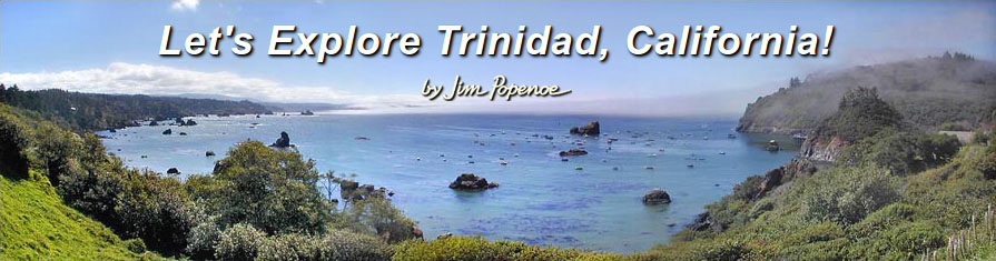
Trinidad, California is a small town on California’s north coast. Much of the Trinidad area is well above the ocean on marine terraces. The terraces are bordered by rugged bluffs with spectacular ocean vistas. In the panorama above, we look south in town from the bluff near the flag pole on Edwards Street. On the left side is Trinidad's Scenic Drive coast. On the right side are Trinidad Harbor and Trinidad Head.
Below the flag pole are concrete steps, and then a fence blocking access to the overgrown former Axel Lindgren Memorial Trail down to Old Home Beach. It was the home beach of the Tsurai people, and remains a favorite of local residents today. The trail is now closed, but there are alternative trails that we can still take to explore this beach.
From Old Home Beach, if it is low tide, we can go east, scrambling over rocks to cobbly He-Woli Beach. He-Woli Beach is the farthest we can go this way. A high, rocky point blocks further progress. We would have to take the Groth Lane Trail up to Scenic Drive to skirt around the point.
Going west, Old Home Beach ends at a jumble of boulders. Launcher Beach is on the opposite side. I only try to cross at low tide. The wet rocks are slippery, and others are rough with sharp edges. I stow all my gear in a pack to keep my hands free, and I wear leather gloves for protection. Atop the boulders we can enjoy close-up views of Trinidad Bay, Trinidad Head, Launcher Beach and Old Home Beach. The only sound is small waves lapping. . . From here, we can continue over the rocks to Launcher Beach, the harbor area and beyond.
Normally, to reach the harbor area, I walk or drive down Edwards Street to the waterfront parking. At the east end is Launcher Beach, a favorite place to launch small boats and kayaks into Trinidad Bay. There is a rail launch for larger boats. The Trinidad Pier is south between Little Head and Trinidad Head. We can walk to Trinidad Head and Trinidad Beach from here, too. Trinidad's trails are well connected for walking.
The Trinidad Head loop trail climbs 350 feet and boasts views in every direction. Allow about an hour for this hike. My Trinidad Head map details what you can see from the trail.
Along Scenic Drive are many small beaches and coves, sea stacks, and rocky bluffs with spectacular vistas. Trails lead down to Luffenholtz and Baker Beaches, and out to Houda and Tepona Points. My Scenic Drive map shows just where.
Trinidad State Beach is a recreation area that adjoins Trinidad on the north side of town. See my Trinidad State Beach map. The entire State Beach is accessible on foot from town, but it has two parking lots of its own. At the southern parking lot is an open grassy area with picnic tables and a restroom. A path leads down to Trinidad Beach at the mouth of Mill Creek, with views of Pewetole Island along the way. Trinidad Beach is a wonder to explore at low tide. See reflections of Pewetole and Trinidad Head in the wet sand. Look up at the towering, jagged rocks. Walk to the sea arch. Study the abundant intertidal life.
A 0.9-mile trail connects the southern and northern parking lots, and unifies the State Beach trail network. The south end of the connector trail follows the Mill Creek canyon under a mix of red alder, Sitka spruce and big-leaf maple. The air is moist and full of the sound of rushing water. A dense understory of ferns protects the steep slopes. Please be sure everyone stays on the trail to guard these fragile slopes from erosion. To fully enjoy the canyon, walk the trail at different times of year. Mill Creek can be a torrent in winter, but diminishes to a trickle by the end of summer. And around the bridge over Mill Creek, the look of the woods changes with the seasons.
North of Mill Creek, the connector trail ascends to a marine terrace. It is nearly level, and the forest is mainly Sitka spruce. The trail drops once more as we cross the bridge over College Cove Creek, and up again, 480 feet to the northern parking lot.
From the northern parking lot, we can take the Elk Head Trail west toward Elk Head. The trail is on a nearly level marine terrace. The vegetation is alder forest with red elderberry and a few Sitka spruce.
About 800 feet past the trailhead is a fork to the left. Steps descend from the bluff down to College Cove. There is a small waterfall where College Cove Creek empties onto the beach.
Continuing west on the Elk Head Trail past the College Cove Trail, we can stop all along the bluff to enjoy views of College Cove, Pewetole Island and Trinidad Head. The trail forking to the right is a shortcut to Megwil Point. It goes through deeply shaded spruce forest. Let's keep left. The vegetation opens into coastal scrub as we come to a botanical area on Elk Head. There are ocean vista points as the trail turns northwest along the bluff. Eventually the trail begins a gentle descent, ending in steps at Megwil Point.
Sue-meg State Park (formerly Patrick's Point State Park), 10 minutes north of Trinidad, is a big favorite. Great trails and views! Lots to see and do for kids of all ages!
Big Lagoon, 15 minutes north of Trinidad, is fun for wading, agate hunting, fishing, kayaking, sailing, windsurfing and birdwatching.
The redwood parks near Orick are just 25 minutes north of Trinidad. Simply majestic... Allow plenty of time to explore the redwoods, too.
For more photos, information and perspectives, please see my links page.
trinidad.jimpopenoe.net
Trinidad, CA, USA
May 25, 2026